Moon: North Rim of the South Pole-Aitken Basin 25S 170W
Steven Dutch, Natural and Applied Sciences, University
of Wisconsin - Green Bay
e
Scale: 1 pixel = 2 km. 5-degree grid;
Lambert Conformal Conic Projection, Projection Center 00NS 145WE; Map center 25S 170W
Lunar Geology Index Global and Planetary Geology Index
Legend
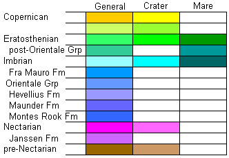 |
Copernican: Beginning with the formation of the
bright crater Copernicus, about 1.1 Ga. Formation of bright ray
craters. Eratosthenian: Begins with the formation of the crater Eratosthenes. Fresh but non-rayed craters and late mare eruptions. 1.1 to 3.1 Ga. Imbrian: Begins with the formation of the Imbrium Basin. Includes most mare eruptions. 3.1 to 3.8 Ga. Nectarian: Begins with the formation of the Nectaris Basin, and includes most of the major impact basin events. 3.8 to 3.9 Ga. pre-Nectarian: Before 3.9 Ga |
Discussion
The northern half of the South Pole-Aitken Basin is shown on this map. It is completely invisible on the geologic map but very evident on the topographic maps. This is the largest, deepest, and oldest recognized basin on the Moon. The highest point on the Moon is in the highlands north of the basin, and the lowest point is on the floor of one of the craters in the interior of the basin. The band of highlands north of the basin may be ejecta from the basin itself, perhaps indicating an oblique impact.
Three of the largest craters on the Moon are visible on this map. Korolev and Hertzsprung are partially visible on the north edge of the map, and, just to add insult to injury, a third crater, Apollo, lies within the basin itself. There are numerous small patches of mare within the basin, where the crust was evidently thin enough to allow lava to erupt.
Lunar Geology Index
Global and Planetary Geology Index
Return to Professor Dutch's Home Page
Created 11 April 2014, Last Update
Not an official UW Green Bay site